A Hike through a pristine forest to
"Tajo de la Caina"

Prologue:"Tajo de la Caina"

The village of Yunquera is situated 50 km to the north of Marbella and 38 km to the east of Ronda.
On a lovely warm autumn day we decided to go for this hike near Yunquera and into the Sierra de las Nieves Nature Park. The hike took us through a large pristine forest of unique Spanish fir trees "Apies pinsapo", which are native to this region of Andalucía.
This area is known for its outstanding beauty, its wonderful views, and also for its biodiversity.
Quite often you are able to see the Iberian Ibex, Cabra Montes, on the rocky slopes of the limestone mountains, as well as various birds of prey (like the golden eagle, peregrine falcons) soaring in the skies.
The hike itself was moderate to more difficult but in all we enjoyed every moment of it. The panoramic views at "Tajo de Caina" are breath taken.

Note: When walking in this high altitudes of the Sierra de las Nieves be sure to wear appropriate clothing as in the winter months you might find snow in this part of the mountains and often low clouds can appear out of no where and you find yourself surrounded by fog. In this case make sure you find yourself on a proper pathway. Of course take plenty of water with you.


- The Hike is a 5,3 km moderate to difficult hike on a narrow mountain path, which takes you to an altitude of 1271 m above sea-level, the differences are 325 meters.

- From Marbella A-7 you take the road towards Ojén A-355.
- Drive onto Monda there you turn towards Guaro/Ronda A-366. You bypass the villages of Guaro, Alozaina and Jorox.
- You reach Yunquera after 47 km and approx. 1 hour drive.
- In Yunquera you stay on the Ronda road until you reach a roundabout, where you take the 2nd turning towards Sierra de Nieves Nature Park (Parque Natural Siera de las Nieves) and the Sports ground (Complejo Deportivo).
- From the Roundabout you drive for about 7,2 km on a forest road until you reach the Viewpoint of Mirador de Luis Ceballos.
- It is from here, where we started our hike to the "Tajo de Caina"

From the village we drive about 4 km carefully drive up a well maintained forest road
before we enter the Nature park of Sierra de las Nieves.
before we enter the Nature park of Sierra de las Nieves.
Note in summertime you might find the gates closed for cars due to fire risks.
From there it is another 2 km approx. to the viewpoint Mirador de Luis Ceballos.
As we carefully precede, we become aware of the magnificent nature area, various trees line
the road, like Aleppo pine, Cork and Gall Oaks, Chestnut trees, and many more.
the road, like Aleppo pine, Cork and Gall Oaks, Chestnut trees, and many more.

An Information board informing you about the
Sierra de las Nieves nature park.

Sierra de las Nieves was declared a Nature Park in 1989, it is located in the western part of the Málaga Province, bounded to the south by the western Costa del Sol, to the east by the Guadalhorce Valley, to the west by Sierra of Ronda and to the north by the district of Guadalteba.
The park covers an area of 20.163 hectares. Yunquera is one of the 9 municipalities which share the Nature Reserve. The most striking features of the Sierra de las Nieves are the brilliant white and fairly bare looking limestone mountains. The highest peak is the mount Torrecilla (1919m).
The park covers an area of 20.163 hectares. Yunquera is one of the 9 municipalities which share the Nature Reserve. The most striking features of the Sierra de las Nieves are the brilliant white and fairly bare looking limestone mountains. The highest peak is the mount Torrecilla (1919m).

You are standing at approx. 1100 meters above sea-level,
the panoramic views are stunning.

It is a big open space which gives you a window to the Nature Park and you will find some information boards here, which give you an insight of this unique area of the Sierra de las Nieves.


The 360º panoramic views are fantastic.
The village of Yunquera in the foothills of Sierra Cabrilla.

Luis Ceballos y Fernandez de Cordoba (1896 - 1967)
Engineer of mountains, Botanist, Professor and Academic

Poem taken from the rock carving.
Do not ever avoid contact with the mountains, go to the fullness of curiosity and
spirit of observation, be willing to see and feel, appreciating all the details of your moment.
spirit of observation, be willing to see and feel, appreciating all the details of your moment.
 |
| Spanish fir, Apies pinsapo |
An information board explaining the facts about the significance of the Pinsapo trees in this area.

The Spanish fir, El Pinsapar (Abies pinsapo) is a species of fir found in southern Spain and northern Morocco. Related to other species of Mediterranean firs, it is considered the Andalusian National Tree, and is native to the Andalusian mountains. It appears in the Sierra de las Nieves by Ronda, and Sierra Bermeja in the province of Málaga and Sierra de Grazalema in the province of Cádiz at an altitudes of 900 - 1,800 meters.

Apies pinsapo can reach a height of 20 - 30 meters. They have to withstand very harsh conditions, very cold winters as this area is very often covered in snow, and very hot dry summers. They are able to pick up the moisture from the air with their short dense needles.
Information taken from board.

Cabra montes, Iberian Ibex
La reina de las cumbres, the queen of the peaks

This species of mountain goat Cabra Montes is unique to the Iberian peninsula and about 35000 are found in the mountainous region of Andalucía. They are fully adapted to the rocky slopes and harsh climates. Hot dry summers and cold winters with snow covered peaks.
Towards the right of the viewpoint you find a narrow footpath which is the starting point to your hike. After 100 m, the footpath branches off, and we follow the left path downwards.
The information board gives you a brief description of the walkway.

Did you know why this deep cleft in the mountain (el Tajo) was known by the name of "la Caina".
According to legend, a lady named Caina and of scandalous behaviour was tried and convicted to be burned. After a long process, it was decided that the woman whose feminine name was Cain, could not be executed in any way, the high clergy proposal to be disregarded ,and it should be seen as a lesson and education for the inhabitants of Tolox and Yunquera.
Information taken from board.

For the first 500 meters we follow the trail downwards.

This path let us into the pristine forest of Pinsapos.

Wilted thistle on the wayside.


Newly planted oak trees are protected by a wire mash.

We admire these magnificent trees.

Apies pinsapo can reach a height of 20 - 30 meters.

Across the valley we see the path we came on.

In the distance the Mirador Luis Ceballo.

From now on it goes steadily uphill and deeper into the Pinsapo forest.

El Pinsapar de los Lajares
This dense dark green forest that extends before you is the Pinsapar de los Lajares,
named for the special arrangement of limestone slabs, on which the forest Pinsapos sits.
named for the special arrangement of limestone slabs, on which the forest Pinsapos sits.

A view north and towards the Mirador, our starting point.

From here we get a glimpse of the limestone peak of Picacho.

A view east towards the coast of Málaga.

The arrow on the pole indicates the direction of the route.

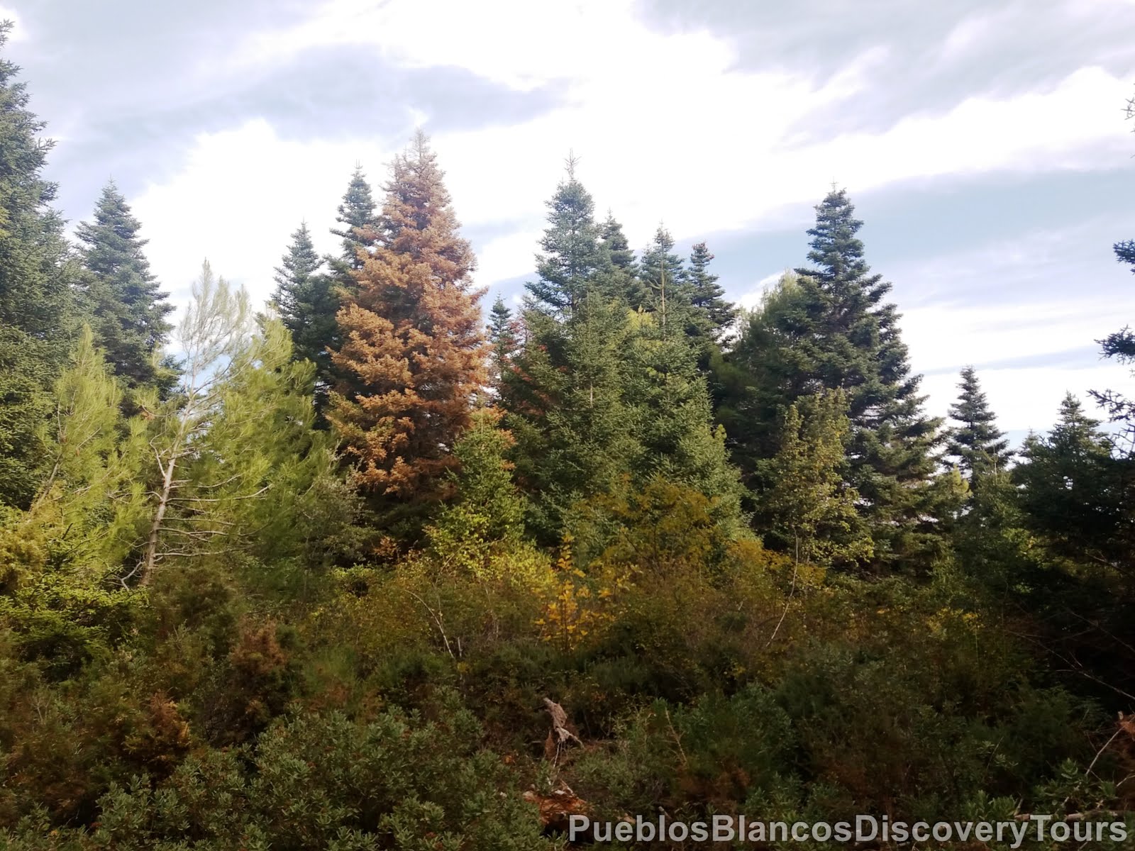
On this section of the trail we see many trees that are affected by a fungus
and they seem to be dying.


It seem that insects have done their work at this tree stem.

Branches are covered by lichen.

Between and on the rocks you find lichen, moss and succulent plants.

Blooming moss.

Some mushrooms in the undergrowth near the footpath.


This stretch looks more like walking through a ghost forest.

Still standing tall, it must've been a magnificent tree once!

A view north between the trees and towards
the Sierra Cabrilla and Sierra Prieta.

To the west El Picacho.


We followed a cobble stone path which leads us to a plateau and and ancient Era.

"Era de los Gamones".
Eras are paved circular areas located in well vented places.
They were used by farmers for threshing cereal harvests.

The 360º Panoramic views are totally amazing!

To the east towards the bay of Málaga.

To the west El Picacho and Puerto del Saucillo.

Facing south Cerro del Chaparral.

The last blooming rock rose of the year.

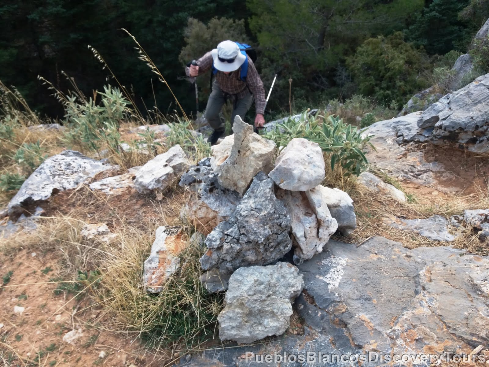
As we tried to climb higher we stumbled across brilliant sparkling rocks.

Natures wonder, totally fascinating!

Sitting on a crystal stool!

We returned back to the way-sign and headed towards
Vista Panorámica, 750 m to Tajo de la Caina.


The footpath leads us through some more forested area.

A triple tree out of one stem, fascinating!

and rather huge too!


We have reached a high plateau at approx. 1270 meters,

and at this point it also seems the end of the tree line.

The panoramic views are stunning.
Breathtaking views of "Tajo de la Caina"

We have reached the end of the official pathway and a sign warning us of the danger of falling over the cliff.

But we avenged on as we saw a well used track leading below the rock face.
A view across and towards the highest peak of the Sierra de las Nieves
(Torrecilla 1919 m).

And this view is towards the Mediterranean coast, Sierra de Mijas and Sierra de Coín.


As we skim the rock face above us, we hoped to see Iberian Ibex (Cabra Montes),
but unfortunately not today.


But we were able to see birds of prey and many swallows sweeping around us.


This rock makes an ideal picnic spot.

Can't fail the fresh mountain are, the tranquillity and the amazing views.

The valley below us leads towards the village of Tolox.

In the distance the Sierra Blanca with the peak of La Concha (1270 m).

Some dainty flowers in the crevasse.

It looks like that every cap in the rook is taken by succulents.

After the picnic feeling refreshed we headed back to the way-sign and we followed the direction towards the Mirador Luis Ceballos.

This trail seems much steeper and less used.


A view back up.


How long is this majestic tree still standing strong.

Carefully we stroll on.


1,4 km to the Mirador Luis Ceballos

While getting the breath back we enjoy the scenery.


Having reached the bottom of the valley an arrow points steep upwards.


The final climb up.
The viewpoint is touching near.

A stone bench at the viewpoint was welcoming, to take a last look across the beautiful, unique and majestic Pinsapo forest.

A final panoramic view before we headed home.

Map of the Hike
 |
| Wikiloc: Tajo de Caina, Yunquera |

No comments:
Post a Comment