Benalauría


The cheese factory near Casares

In the shop you can buy delicious goat cheese and other local products.
You also can take a tour of the factory at certain times.

At a viewpoint before Gaucín
.jpg)
you get a good view of the village when looking towards the north and to the south the view reach as far as the coast and Campo de Gibraltar.

Gaucín is the gateway to the Serrana de Ronda.

The viewpoint Mirador de Gaucín

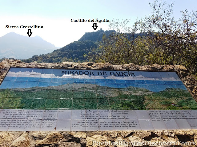

Very often at the viewpoints you find interesting information boards,


Looking back towards the Sierra Crestellina

A small chestnut tree displays its autumn colours.

Mirador del Genal, the viewpoint of the Genal


The village of Algatocín at 725 meters


The villages are like white dots amidst the lush hillsides.
Seen here Jubrique on the right and Genalguacil on the left.


About 3 km after Algatocín you reach the crossroad towards Benalauría.

And from there it is a 2 km windy narrow road leads to the village.


We walked among the narrow alleyways of this picturesque little village.


The village is built on a steep hillside.

You will find many flower covered walls and patios.


This building is like a set out of a fairy-tail.


You can almost breath the history !


The building of the town hall (Ayuntamiento) dates from the 18th century.

Houses from that period are known for their grandiose entrances and wrought iron balconies.


The village square, Plaza Teniente Viñas.

The village fountain, Fuente Grande.


Lizards guarding the entrance!

We had a lovely lunch at a cozy little restaurant.

Bar La Trocha in Calle Alta

A last look back at Benalauría,
and then we carry on with our tour towards Ronda.

Our next stop was the viewpoint of the Chestnut trees.

Mirador de los Castañares

This view takes you towards the east
and in autumn the chestnut forests are most noticeable.

Mirador de Atajate

The view towards the coast and the village of Atajate.

Mirador de Fraile
The limestone rock (Cerro del Fraile) in the background.

This viewpoint is not far from the village of Alpandeíre,
which is the birthplace of the Friar Leopoldo.


This sign reads, Alpandeire Land of Faith, Water and Light
Alpandeire Tierra de Fé, de Aqua y Luz.
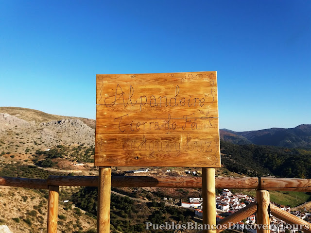
The village of Alpandeíre below us.

Our next stop was the little village of Faraján.


if only for the panoramic view,
which presents itself to you from the terrace at the back.

We carry on and drive through a cork oak forest.

The evening sun shines upon the blue village of Juzcár.

It is also known as the Smurf village or Pueblo de Pitufos.

Chestnut trees line the road.

Again the road takes us through the karst mountains of
Sierra del Orgenal.

The map of the round tour

Prologue:
On this route we wanted to have a closer look at the village of Benalauria. It is a small but very pretty village in the lower Genal valley with just 500 inhabitants. Situated on a steep slope, east facing, surrounded by chestnut trees.
It is an archetypal Moorish village with white washed walls and narrow alleyways.

Directions:
- We started our tour in the south/west part of the Serranía de Ronda in the Lower Genal valley.
- Our first stop was the cheese factory/shop just after the crossroads of Casares on the Manilva/Gaucín A-377.
- Then we headed towards the village of Gaucín and thereafter in the direction to Ronda A-369.
- On the way we stopped off at various Viewpoints (Miradors), which gave us good overviews of the Genal river valley.

- About 10 km from Gaucín is the turn off to Benalauria MA- 8306.
- The village is another 2 km from the crossroad.

- After a good stroll round the village and very nice lunch, we set off on our journey towards Ronda.
- We took the turning towards the villages of Alpandeire, Farajan, Juzgar and Cartajema before we headed back to the coast on the Ronda - San Pedro de Alcantara road .
- The round trip is about 174 km when starting from Marbella.

Whilst driving through this region taking in the views and the geography, you seem also, to breath in the history from the times of the Visigoths, Romans, Moors and Christians until the modern day.
Not only the wonderful landscapes, and the changing hues are a feast for the eyes but also, the biodiversity makes this area a treasure to be relished.
The cheese factory near Casares

In the shop you can buy delicious goat cheese and other local products.
You also can take a tour of the factory at certain times.

At a viewpoint before Gaucín
.jpg)
you get a good view of the village when looking towards the north and to the south the view reach as far as the coast and Campo de Gibraltar.

Gaucín is the gateway to the Serrana de Ronda.

The viewpoint Mirador de Gaucín

is situated on the Ronda road A-369, just a few km after the village Gaucín.

Mirador Asalto del Cura, viewpoint of the assault of the priest.

Very often at the viewpoints you find interesting information boards,

as well as picnic tables

On this board are some of the birds which can be seen here.

Looking back towards the Sierra Crestellina

A small chestnut tree displays its autumn colours.

Mirador del Genal, the viewpoint of the Genal

This viewpoint is certainly worth stopping for. There are various routes around a hill and you are presented with panoramic views of the Genal valley.

The River Genal and it's valley form an important part of Serranía de Ronda region. It is classed as a natural monument for diversity of Flora and Fauna. The most characteristic tree species are the chestnut trees which are cultivated here. There are 15 municipalities around the Genal valley and it is divided into two parts, Higher and Lower Genal.
The limestone mountains of Ronda gives the Genal valley some protection against the cold in the winter and also the summer heat.

The village of Algatocín at 725 meters


The villages are like white dots amidst the lush hillsides.
Seen here Jubrique on the right and Genalguacil on the left.

Autumn is especially picturesque in the Serranía de Ronda, it is the time of year when the leaves of the chestnut trees change their colour from green to yellow to orange and brown. The Genal valley is known for its chestnut forest, it also goes by the name of The Copper Forest (el Bosque de Cobre).

We stopped off at a road side shop near the village of Algatocín.
There you can find local produce as well as handicrafts.
There you can find local produce as well as handicrafts.

About 3 km after Algatocín you reach the crossroad towards Benalauría.

And from there it is a 2 km windy narrow road leads to the village.

Benalauría forms part of the Almorávides and Almohades route. They were Berber tribes from north Africa which settled in this area in the 10th century. The village got its name from the Berber tribe of Banu-I-Hawria. They settled in this area in the 8th century and cultivated the hillside.
After the Christian conquest in 1485 the Moors known as Mudéjares stayed in the area under the jurisdiction of Counts of Fería.
In the 18th century the population increased drastically from 383 to 885 due to favourable economic conditions in this area. It was also at this time that the church Santo Domingo de Guzmán was rebuilt, and the town hall and the main square as well as many other buildings were constructed. The 18th century architecture is still visible on many of the facades of houses in the village.

We walked among the narrow alleyways of this picturesque little village.

You will find many nooks and crannies.

Benalauría has kept its Moorish charm,
and its heritage is reflected in the architecture of the houses, even today.


The village is built on a steep hillside.

You will find many flower covered walls and patios.


This building is like a set out of a fairy-tail.


We come across an intriguing passageway!

It looks very old and quaint!

You can almost breath the history !

This narrow passage leads to a square.

Centro de Interpretación Casa de Moros y Christianos
The interpretation centre the House of Moors and Christians

The Moorish spirit in Benalauría is very much kept alive in memory and tradition. In the House of Moors and Christians you learn about the Islamic past of the the Serranía de Ronda and the battles fought by the Catholic Monarchs in the Reconquest of the Iberian Peninsula.

Benalauría is proud of its historic past and every year on the first Sunday in August, in honour of Santo Domingo de Guzmán, they relive the time of the Christian conquest over the Moors which took place in this area.

The building of the town hall (Ayuntamiento) dates from the 18th century.

Houses from that period are known for their grandiose entrances and wrought iron balconies.


The village square, Plaza Teniente Viñas.

The village fountain, Fuente Grande.

The village bakery (Panadería) to the right


Lizards guarding the entrance!

We had a lovely lunch at a cozy little restaurant.

Bar La Trocha in Calle Alta

 |
| Roast pepper salad with oranges, Enselada de Pimientas. |
 |
| Fried mushrooms, Setas fritas. |
 |
| Pork stew, Estofado de Cerdo |
A last look back at Benalauría,
and then we carry on with our tour towards Ronda.

Our next stop was the viewpoint of the Chestnut trees.

Mirador de los Castañares

This view takes you towards the east
and in autumn the chestnut forests are most noticeable.

Mirador de Atajate

The view towards the coast and the village of Atajate.

Mirador de Fraile
The limestone rock (Cerro del Fraile) in the background.

This viewpoint is not far from the village of Alpandeíre,
which is the birthplace of the Friar Leopoldo.

At about 900 meters above sea level, a total different scene presents itself to us,
it is very bare and scarce of vegetation.

The road MA-7307 follows alongside the Sierra del Oreganal.

This view takes you along the Genal valley and towards the coast.


This sign reads, Alpandeire Land of Faith, Water and Light
Alpandeire Tierra de Fé, de Aqua y Luz.

The village of Alpandeíre below us.

Our next stop was the little village of Faraján.

We had a coffee at this restaurant and it is worth recommending

if only for the panoramic view,
which presents itself to you from the terrace at the back.

We carry on and drive through a cork oak forest.

The evening sun shines upon the blue village of Juzcár.

It is also known as the Smurf village or Pueblo de Pitufos.

Chestnut trees line the road.

Again the road takes us through the karst mountains of
Sierra del Orgenal.

The map of the round tour
Related Blog:
No comments:
Post a Comment