A hike to a viewpoint, across a dam and to the entrance to a cave
Mirador del Hundidero, Presa de los Caballeros,
Cueva del Hundidero


Prologue:
The natural area of Hundidero, near the village of Montejaque is just 20 minutes drive from Ronda in the direction Sevilla. It is a nature lovers paradise, apart from the hiking trails, it is rich in fauna and flora. There is a bird observatory set upon a hill and in spring and autumn many migrating birds can be seen here. The large Griffon vultures (Buitre Leonardo) which find there resting place in the many caves and crevasses are numerous here.
From the carpark of Hundidero you will have various options of trails. From a fairly easy one to a viewpoint across two dams, or to a bird observation point. For the more daring and experienced rock climbers there are special laid out routes (Via Ferrata) including a suspensión bridge, and there is a cave Cueva del Hundidero to explore. (Note check the regulation before entering find out more from the Montejaque's Speleology Society).
The gorge and the surrounding area of Hundidero form part of the limestone mountains of the Nature park of Grazalema (Parque Natural Sierra de Grazalema). The nature park is shared between the Cádiz and the Málaga province. The municipality of Montejaque is situated in the Serranía de Ronda in the western part of Málaga Province. In 2019 the cave Hundidero was declared a National Monument (Monumento Natural Cueva del Hundidero).
.jpg)
Direction:
- Leave the autopista A-7 in San Pedro de Alcántara, drive towards Ronda A-397.
- Bypassing Ronda town centre, you head towards Sevilla A-374 taking the 3rd exit at the roundabout.
- After 14,3 km/15 min. turn left towards the village of Montejaque MA-8403
- After 3,3 km turn right onto a large carpark. The walking trails starts here.
.jpg)
In front of us the mountain range of Sierra de Libar, Sierra Algarrobo and Cima Mures,
which forms part of the Sierra de Grazalema Nature Park.
.jpg) |
| The summit of Peñon o Lentisco de Mures (859m) |
 |
| Wikiloc: Mirador del Hundidero, Presa de los Caballeros, Cueva del Hundidero |
The Hike is approx. 4,55 km in total, it is divided into three different trails.
1. The trails to the viewpoint Mirador del Hundidero is a 900 meters fairly easy walk.
2. The trail to and across the dam Presa de los Caballeros is a little more daring because of vertigo, but the sight is quite impressive.
3. The trail down to the entrance of the cave Cueva del Hundidero is 700 meters and mostly steps with a difference of 80 meters in altitude.
Note: Even though the trails are well maintained and with security fences, it is recommended to wear good walking shoes and carry some water with you.
.jpg)
Monumento Natural Cueva del Hundidero
In Spain, there are only two rivers that are hidden, continuing in underground currents, and reappearing later, our rivers Guaduares or Campobuche and the river Guadiana, which reaches a point where it is lost and reappears downstream, in the so called "Ojos del Guadiana"
Whilst more than 50 meters high, the Hundidero Cave is located at the bottom of a gorge through which the river circulates, forming the Hundidero-Gato system.
The Guaduares river crosses through the Mures and Algarrobo mountain ranges in this way to reappear through the Gato Cave separated by more than 4 km from the entrance, forming the most impressive underground fluvial space in our geography.
Information taken from board.


There are various information boards near the carpark and at the start of the trail.
.jpg)
Our first destination was the viewpoint of "Mirador del Hundidero"
.jpg)
Making its way through the dizzying rocky escarpments of the Mures, Tavizna and Taviznilla hills, this trail crosses the heart of the Cueva del Hundidero Natural Monument, to take you to one of the most impressive places in the Sierra de Grazalema Natural Park. The Mirador del Hundidero is immersed in a karstic landscape of overwhelming power and beauty, whose limestone walls are home to various species such as Spanish Ibex, the Leonardo vulture, the Bonelli's eagle, the Alpine swift and the blue rock thrush.
The route shares the first 500 metres with the Cueva del Hundidero and Presa de los Caballeros trails. On a sharp bend, it turns left in search of the Hundidero viewpoint, along the old route of the wagons that transported materials for the construction of the dam. In this reservoir, the Guadares or Campobuche river, which created the spectacular Hundidero chasm, loses its course. This cavity is the entrance to the so-called Hundidero-Gato System: the river enters the Cueva del Hundidero and flows along 8 km of underground galleries, until it comes to the surface at the Cueva del Gato.
Information taken from Information board.

The hike to the viewpoint is an easy walk,
their are stunning panoramic views along the way.
.jpg)
In 2019 the cave Hundidero was declared a National Monument
(Monumento Natural Cueva del Hundidero).
At the crossroad we turn left and follow the way signs towards the viewpoint
"Mirador del Hundidero".
.jpg)
Straight ahead the dam Presa de los Caballeros which we keep for later.
Below the dry lake basin.
.jpg)
%20-%20Copy.jpg)
The trail to and from the viewpoint is a leisurely 900 meters.
.jpg)
The footpath narrows as it leads alongside the rock face.
.jpg)
We are surrounded by the karstic landscape.
.jpg)
Very dramatic and fascinating!
.jpg)
.jpg)
we noticed a Griffon vulture high up on the cliff.

The panoramic views are breath taking.
.jpg)
A view south and towards the dam "Presa de los Caballeros".
.jpg)
From here we look down to the trail which leads to the entrance to the cave.
.jpg)
A precarious looking rock!
.jpg)
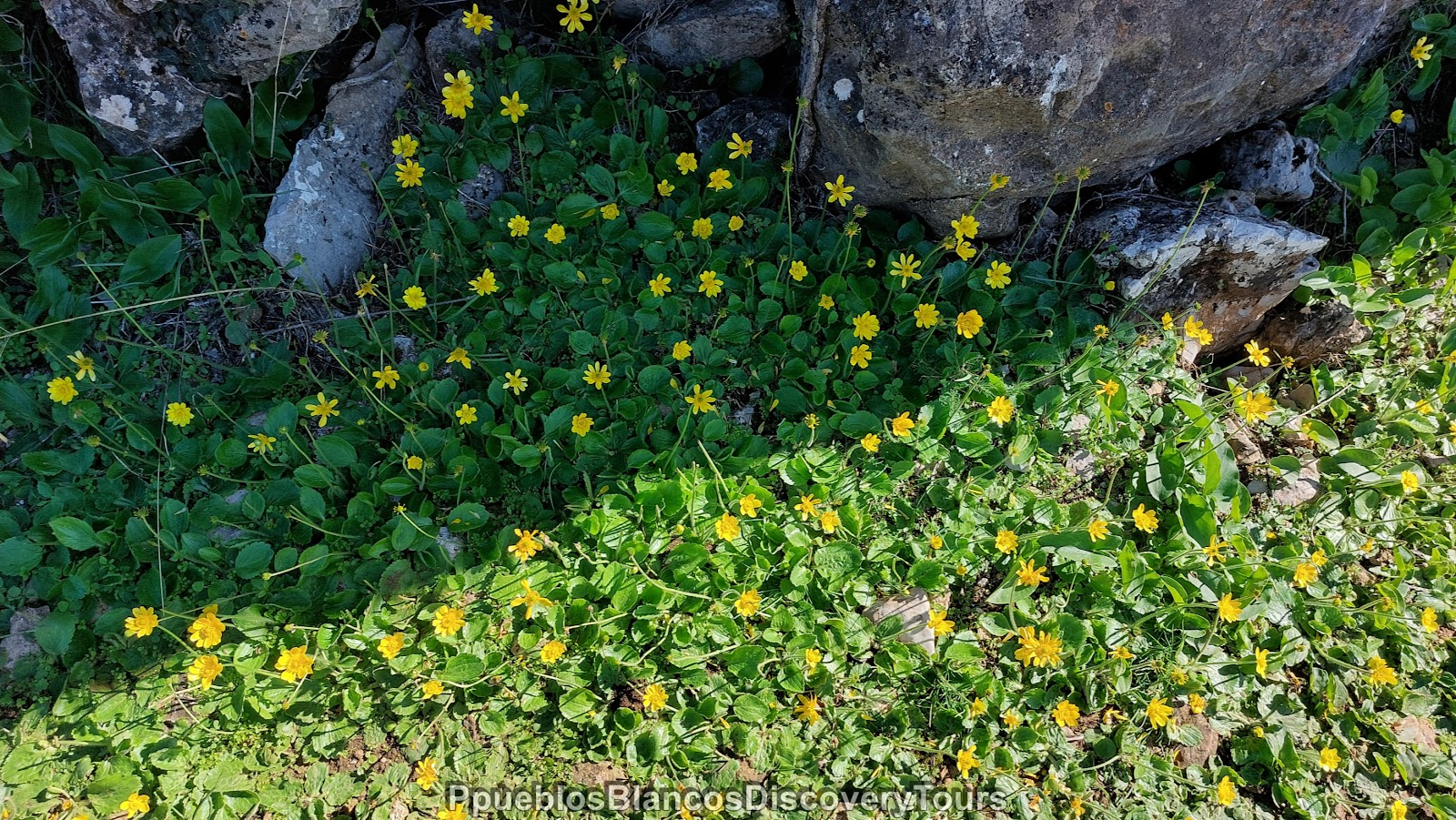
Yellow flowers line the pathway.

A hawthorn bush full of red fruit.

.jpg)
At the end of the footpath you come to the viewpoint of the gorge,
deep down from here is the entrance to the cave.
.jpg)
Two Happy-hikers!
.jpg)

At the dam there are some climbing routes, including a suspension bridge.

As we look towards the sky we notice many Griffon vultures as well as some eagles gliding through the air.

Ahead of us the dam "Presa de los Caballeros".
.jpg)
.jpg)
We follow the path to the right.

There are two dams, first we walk across the smaller one.
.jpg)
A view west, below the dryed out basin of the reservare "Embalse de Montejaque".
.jpg)
Across the gorge we can make out the road which leads to the village of Montejaque, below is the pathway to the viewpoint.
.jpg)
We walk through a gate and up some steps to reach the dam.
.jpg)
Carefully we make our way across.
.jpg)
It is quite exhilarating!
.jpg)
On one side the open land and on the other, the karst rock formations.
.jpg)
We wonder what this rusty box was for.
.jpg)
A view across the gorge.
.jpg)
We watched some rock climbers as they make their way upwards from the gorge.
.jpg)
.jpg)
The suspension bridge looks daring.
.jpg)
We will leave it for the next time! Maybe!!

Incredible panoramic views!
.jpg)
In the distance a lonely farm amidst an olive grove, cork oaks and green pastures.
.jpg)
A security gate marks the entrance to the hanging bridge and to some climbing routes.
.jpg)
.jpg)
The suspensión bridge mesures 70 meters in length!
.jpg)
A last look around before we head back across the dam.
.jpg)
.jpg)
We are pleased to have found this unique place.
.jpg)
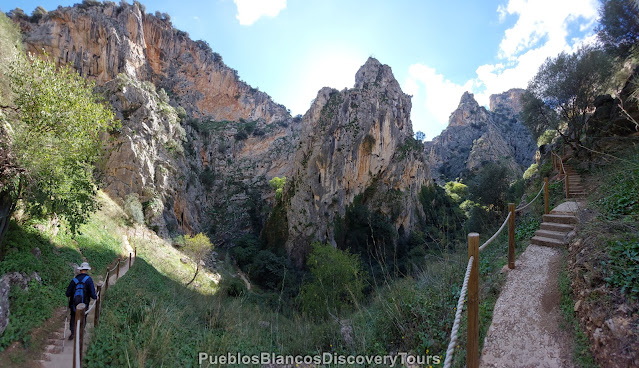
We retrace our steps, and then follow the trail downwards to the entrance to the cave Hundidero.
.jpg)
The footpath looks very inviting,
we try to forget that it is a decent of 700m and approx. 80m steep.
.jpg)
Many, many steps downwards!
.jpg)
Taking in the views again!
.jpg)
.jpg)

Step by step we are get nearer to the bottom of the gorge.

Looking up we notice the Griffon vultures gliding through the air and then disappearing inside the rock.


The limestone rock amongst the clouds - it looks so dramatic!

Amazing natural surrounding!

Soon we will reach the bottom of the gorge.
.jpg)
A small footpath leads up the gorge and to some climbing routes.
.jpg)
At the bottom of the gorge you find a total different vegetation.
.jpg)
Moss, lichen and various succulents cling to the rocks.
.jpg)
We feel so small standing here.
.jpg)
This huge opening marks the entrance to the cave Hundidero.
.jpg)
It feels very damp and cold here.
.jpg)
.jpg)
This is as far as we allowed to walk without authorisation.
.jpg)
The sky seems sooo far away!

Intriguing but also scary in the same time!


At a slow pace, we make our way back uphill.

Heading back to the crossroad we climb up a small hill to the bird observatory.

A beautiful illustrated information board gives you an insight into some of the birds to be observed.

As we look towards the sky we notice many Griffon vultures as well as some eagles gliding through the air.

From here you have a 360º views.
.jpg)
An ideal spot to take in the surrounding area and who knows what you might see!
.jpg)
.jpg)
.jpg)
The dam "Presa de los Caballeros" and deep down the dry reservoir
"Embalse de Montejaque".
.jpg)
This makes a good place for a picnic.

Map of the hike


Related blogs: Benaojan to Jimera de Libar along the river Guadiaro
No comments:
Post a Comment