On the Pathway of Vereda Ubrique - Las Asomadillas,
Mirador Puerto de las Asomadillas, Rio Hozgarganta
Mirador Puerto de las Asomadillas, Rio Hozgarganta
Los Alcornocales
Part 2 of the hike


212 meters above sea-level.


The sight of a way pole indicates that you are on the right path.

A view back up towards the main road Jimena dlF to Ubrique.

A pile of stones, laid by human hands, shows us the way.

A majestic cork oak tree.

The cork is harvested every 9 - 12 years.
All of a sudden the trail opened up again and it was easier to follow.


We followed the forest road for approx. 200 meters

before we turned again to a footpath.


An information board beside the trail near the river.
A gate is the last hurdle before you reach the river.

The way sign tells you that you have covered 1,3 km so far and it is 3 km to the village from here.

A view across the river Hozgarganta.


As we were sitting here we could hear goats passing on the other side.
After a rest we follow the path to the left of the marker and

along the rivers edge towards the stepping stones.

The riverbed seems very wide at this point and


It must be nice when the oleander bushes are in bloom here.

As we reached the waters edge the stepping stones abruptly ended.

We searched for an alternative route.

But the big boulders of rock made it very hard to walk along and

it was impossible to see the footpath trough the dense vegetation.

So again we headed back to the stepping stones

and we followed some natural stones to make the crossing.
Luckily without getting wet feet!


Very often you find birds of prey circling the skies, and in the summertime
Bee-eaters and Kingfishers at the riverbank.

Fortunately the footpath on this side of the river was well used ......
by goats!!

The arrow pointing down stream and the way back to the village.

The rocky path gently slopes upwards,

but generally it was easy to follow.

Every now and then we stopped, to take in the ........airs.

Amidst pure nature, wild and rugged!

This giant rock looks like a Picasso work.


With all this markings we surely can't get lost.

A view down river.

In the middle of nowhere it seems,
we found a group of Iberian pigs hiding in the bushes.

Natures artwork!

Quite amazing!


These rock boulders are mainly sandstone.

Wind and rain has shaped the landscape.

We are nearing a clearing in the forest.

A lonely goat, which lagged behind the rest!

Ahead of us an isolated finca, with various farm animals.


We tried to find a path around the farm.


A view across the river valley.

Ahead of us the


This time the river crossing was easier even so we better took our shoes off.

Just up the road and we are back at our starting point.

A view back to the river clearing.


Very often you are able to see cows and horses grazing near the river,

or just taking a sand bath.

Some of the wildflowers we came across on the trail.

Various rock-roses (Jara, Cistus) white, pink, big and small.

We reached the road into the village, but we turned left to where our car was parked.

Map of the complete hike
How to get to Jimena de la Frontera

Part 2 of the hike

Prologue:

The 2nd part of the hike was a little challenging because of the dense vegetation at the start of the trail near the road CA-8201 at "Puerto de las Asomadillas" and, because of the heavy winter rains, the stepping stone bridge over the river was partly washed away. But we were compensated with outstanding beauty and the untamed nature of the river valley Rio Hozgarganta. This area is very rich in fauna and flora and in addition farm animals are allowed to roam freely through the undergrowth.

Jimena de la Frontera is situated in the south east of the Cádiz Province and on the top end of Campo de Gibraltar. The river Hozgarganta flows its whole length of 35 km through the Nature Park and enters into the Guadiaro river. The surrounding countryside along the river is virtually untouched and is of outstanding beauty.
When thinking of Los Alcornocales, what comes to mind is the pure rugged nature, both untamed and very lush. Los Alcornocales Nature Park was declared a Nature Park in 1989 and it is one of the biggest in Spain, with an area of 167.767 ha. It reaches from the Straits of Gibraltar to the mountain ranges inland, including the municipalities of Cortes de la Frontera and Ubrique.

Directions:
- Coming from Marbella on the A7 take the turn off by Guadiaro near Sotogrande towards Castellar de la Frontera A-2100.
- When you come to a crossroad turn right towards the village of Jimena de la Frontera A-405.
- You pass through the village of Los Angeles and carry on towards Ubrique CA- 8201.
- After 2 km you turn left towards Jimena driving past the Camping of Los Alcornocales. You enter Jimena from the north. There is plenty of parking along side this road.
- It is about 1 1/2 hour drive to get to the village of Jimena de la Frontera coming from Marbella.

The itinerary to the Hike:
It is a 8,1 km circular route of medium to more difficult due to dense vegetation, no bridge at river crossing. and a lack of route signs. I like to divide the hike into 2 parts. There is total height difference of approx. 250 meters, the highest point at 320 m and the lowest 70 meter.

- Part 1 starting point is at the north entrance to Jimena dlF. the trail "Vereda Ubrique - Las Asomadillas" to the Viewpoint "Mirador Puerto de las Asomadillas" is a medium walk of 3 km.

212 meters above sea-level.

- Part 2 is a more difficult hike, as the reasons mentioned before, the path starts at the Viewpoint "Mirador Puerto de las Asomadillas" and turns downwards towards the river Hozgarganta from the main road CA-8201 and across the river and back to the village, approx. 5 km.

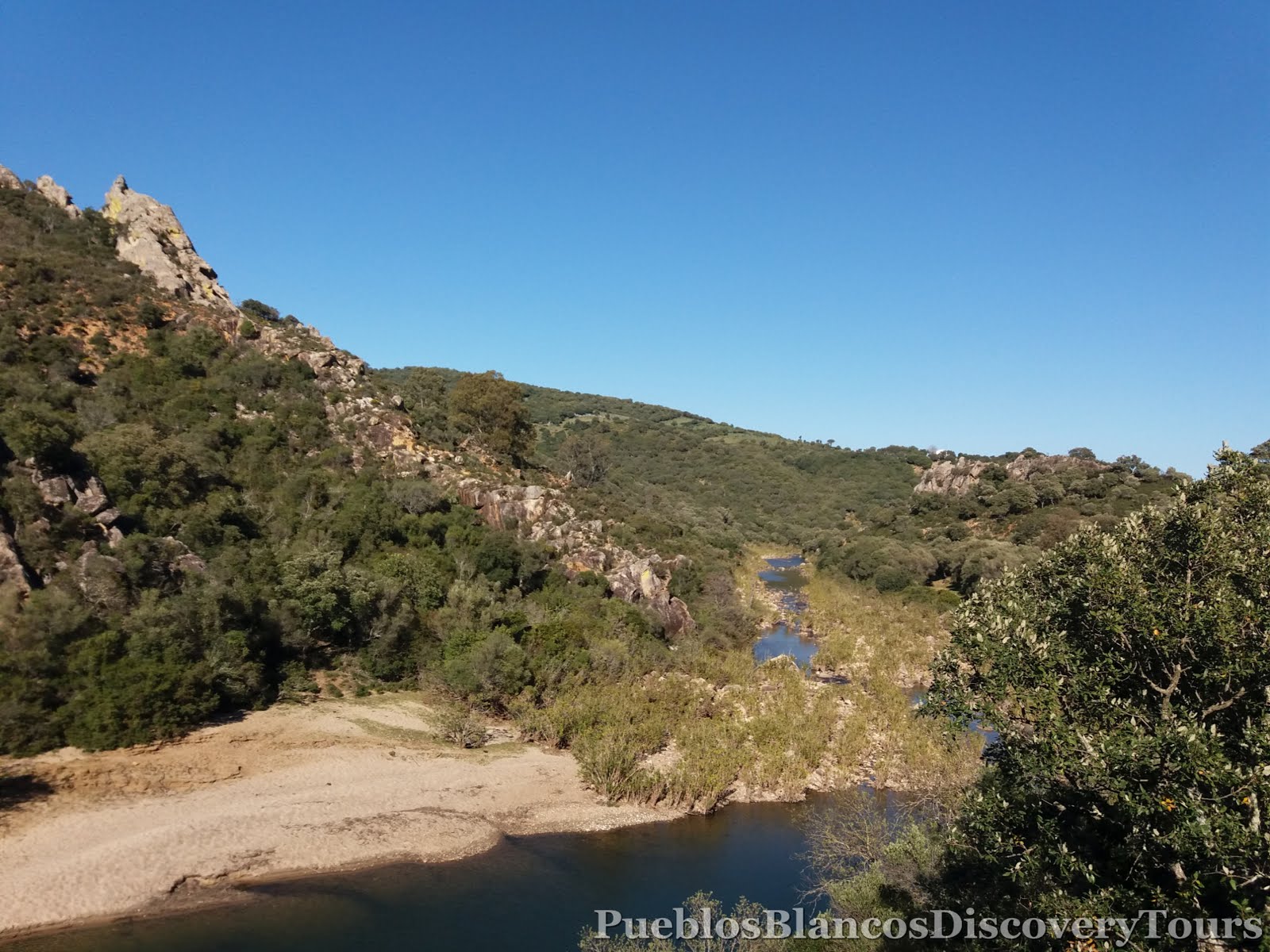
There are few rivers that are preserved in the province of Cadìz in a state as pure as river Rio Hozgarganta.
Walk one of the best preserved corners of the nature park Los Alcornocales, from the northernmost mountain ranges La Sauceda, Pasada Blanca to its mouth in the river Rio Guadiaro.
At a length of 35 km, the river runs through a wide valley that the river has carved over the centuries, and irrigates with its waters the rich plains of Jimena, Castellar, San Pablo de Buceite and San Roque.
It is one of the few river courses lacking regulation in its basin, not presenting any reservoir or dam. This is one of the causes that motivates its biological wealth. We present here a multitude of species of fish, amphibians and insects that require excellent conditions of channel conservation and quality.
Information taken from board.

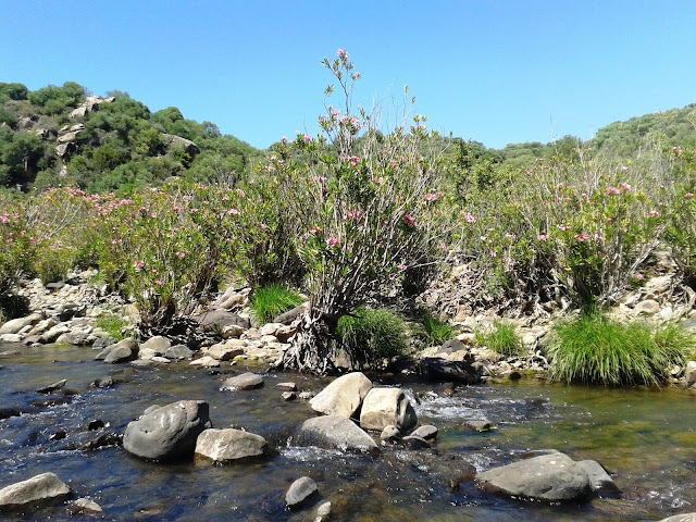
We are in a middle stretch of the river, where, at the riparian zone, abundant bushes grow, and like the oleanders, give a touch of colour to the water flow. The absence of regulation on this river, also conditions the absence of riparian forest, and that the stream of water in times of heavy rainfall increase the water supply, plucking and carrying the possible seedlings that grow. Only the sturdy oleanders and some scrub resist these seasonal floods.
Information taken from board.
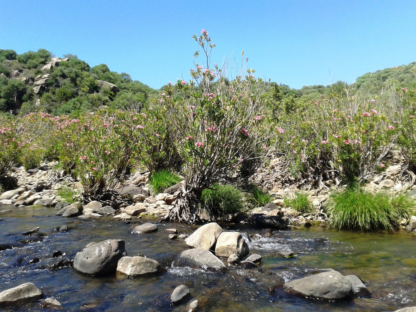
From May - June you will find Oleander bushes in bloom along the riverbank.
 |
| Nerium oleander |
On top of the viewpoint Mirador de las Asomadillas.

From here the 360º panoramic views are fantastic .

The view across the Campo de Gibraltar and towards the coast, the Castle of Jimena (Cerro del Castillo) with the tower (Torre del Homenaje) and the Ethnobotanical gardens "El Risco" with the rock-face of Laja del Águíla and below the river Rio Hozgarganta, and all around us the nature park Los Alcornocales.

Sierra El Hacho to the left and Sierra Bermeja and Sierra Crestelina to the right

This view takes you up river and below us the main road to Ubrique.

We leave the "Mirador Puerto de las Asomadillas" high above us.

and head towards the main road Jimena to Ubrique CA-8201.

A view across the river valley and what lies ahead.

This view is up stream.

Across the road a the way sign, pointing down towards to the river Rio Hozgarganta.


We try to find a way down through the thicket, the path was well hidden.

The sight of a way pole indicates that you are on the right path.

A view back up towards the main road Jimena dlF to Ubrique.

A pile of stones, laid by human hands, shows us the way.

A majestic cork oak tree.

The cork is harvested every 9 - 12 years.
 |
| Read more: Cork oak tree, Quercus suber |


We followed the forest road for approx. 200 meters

before we turned again to a footpath.

Stone pines "Pino Piñonero", which are distinguished from the other pine species by its rounded crown, have been planted in this area as a source of income. This species is not indigenous to the nature park of Los Alcornocales.

An information board beside the trail near the river.
A gate is the last hurdle before you reach the river.

The way sign tells you that you have covered 1,3 km so far and it is 3 km to the village from here.

A view across the river Hozgarganta.

We have found an ideal place for a picnic.

As we were sitting here we could hear goats passing on the other side.
After a rest we follow the path to the left of the marker and

along the rivers edge towards the stepping stones.

The riverbed seems very wide at this point and

the stepping stones made it easier to do the crossing.

A view down stream.

It must be nice when the oleander bushes are in bloom here.

As we reached the waters edge the stepping stones abruptly ended.

We searched for an alternative route.

But the big boulders of rock made it very hard to walk along and

it was impossible to see the footpath trough the dense vegetation.

So again we headed back to the stepping stones

and we followed some natural stones to make the crossing.
Luckily without getting wet feet!

This is a typical view of the Rio Hozgarganta,
rugged and untamed with many huge rocks in its course.

Very often you find birds of prey circling the skies, and in the summertime
Bee-eaters and Kingfishers at the riverbank.

Fortunately the footpath on this side of the river was well used ......
by goats!!

The arrow pointing down stream and the way back to the village.

The rocky path gently slopes upwards,

but generally it was easy to follow.

Every now and then we stopped, to take in the ........airs.

Amidst pure nature, wild and rugged!

This giant rock looks like a Picasso work.

The rock face are covered with lichen and moss.

A view across the river.


A lovely rock pool below us.

With all this markings we surely can't get lost.

A view down river.
In the middle of nowhere it seems,
we found a group of Iberian pigs hiding in the bushes.

Natures artwork!

Quite amazing!


These rock boulders are mainly sandstone.

Wind and rain has shaped the landscape.

We are nearing a clearing in the forest.

A lonely goat, which lagged behind the rest!

Ahead of us an isolated finca, with various farm animals.


We tried to find a path around the farm.


A view across the river valley.

Ahead of us the

Ethnobotanical gardens "El Risco" with the rock-face of Laja del Águíla and to the right the Castle of Jimena (Cerro del Castillo) with the tower (Torre del Homenaje).


This time the river crossing was easier even so we better took our shoes off.

Just up the road and we are back at our starting point.

A view back to the river clearing.


Very often you are able to see cows and horses grazing near the river,

or just taking a sand bath.

Some of the wildflowers we came across on the trail.
 |
| Iris/Pé-de-burro (Gynandriris sisyrinchium) |
 |
| Sawfly orchid, Orquidea avispa or Abejera |

Various rock-roses (Jara, Cistus) white, pink, big and small.

We reached the road into the village, but we turned left to where our car was parked.

Prologue:
Apart from the difficulty we had to find the path from the main road, and the adventurous river crossing, the hike was very enjoyable. We felt in harmony with nature and very lucky to have found this unique location.
Map of the complete hike
 |
| Wikiloc: Sendero Vereda Jimena de la Frontera - Ubrique - Las Asomadillas |

No comments:
Post a Comment