A Walk through the Gorge and to the Roman Baths
Canuto de la Utrera
Baños Romanos de la Hedionda
Baños Romanos de la Hedionda
Prologue:
A walk through this amazing gorge takes you back to the Jurassic period. A fascinating karstic landscape, which has been inhabited for hundreds of thousands of years (1st by Neanderthals and after the Homo sapiens), is now a natural treasure and deserves to be protected. Nearby you find the Roman baths of "Baños de la Hedionda". It was said that the Roman Emperor "Caesar" had them built, and used these sulphurous waters to heal his ailments.
You find this information board on the top end of the gorge.
La Sierra de la Utrera is one of the most unusual landmarks in the extreme west of the province of Málaga, bordering on the rugged landscape of the Serranía de Ronda and the gentle coastal planes which stretch towards Gibraltar.
The terrain is made up of small but fascinating karstic formations, the southernmost of their kind in Europe, crossed by three enclosed valleys running parallel to the coast, which are known as "canutos". These valleys with their vertical sides, apart from cresting beautiful scenery, are a favorite resting area for numerous protected bird species including Bonelli eagles and Egyptian vultures.
Apart from the intrinsic natural beauty of the karst landscape of the Sierra, it is also important to highlight the wealth of the cultural history to be found in this corner of the municipality of Casares. Of particular note is the rich paleontological heritage with findings of considerable numbers of fossils covering the periods from the Jurassic to the Pliocene. There are also remains showing human habitation in the area since the dawn of history, which can be seen by the numerous cave dwellings, most notable the Gran Duque, which go back to the Roman times, and probably the Iberian period, the water mills for girding grain on the Arroyo del Albarrán which date back to the Moorish period, and the most well known of all, the Baños de la Hedionda bath, whose sulphurous waters have been enjoyed by man since time immemorial, and which have come to be recognized as a cultural site of great significance.
Information taken from board.
Directions:
- When coming from Marbella head south on the A-7 in the direction of Algeciras/Cadíz.
- After approx. 30 minutes you reach Sabanillas, and take the 1st exit at the roundabout (Supermarket Lidl km 145) towards Camino de Baños.
- You reach a large parking area after 4km/8 minutes.
- The hike "Sendero Canuto de la Utrera" is just a few minutes walk from here on the left-side in direction the Baños de la Hedionda.
- Note: Best times to walk through the gorge are spring and autumn. Don't forget to take water along and wear hiking shoes, and avoid times after heavy rains. Maybe you will like to take a bathing suit along, in case you want to use the sulphurous baths, which of cause will be best enjoyed in the hottest months of the year. Free entry.

- The Hike is a 2,4 km (one-way) moderate walk through the gorge.
- The 1st part, I would call it quite difficult, because part of it is in a dry riverbed and over large rocks
- The top half of the route is fairly easy as it is wide and less steep.
- There are many way-signs and they are easy to follow.
- Throughout the gorge you will experience the astonishing natural surroundings
The trails starts approx. 100 meters from the car-park towards the left, and at the start you will find an information board explaining the route.
We soon notice the extraordinary landscape we are surrounded by.
Amazing to see the various coloured layers of the rock strata.
The arrow on the pole, points us in the right direction.
A narrow path leads upwards and into the gorge.
High limestone cliffs on either side.
We enter deeper into the densely vegetated gorge.
Stripes painted on a rock signal to us that we are on the right path.
The air is filled with the strong smell of the flowers of the Carob tree.
Along the way, we noticed various Carob trees (Algarrobo) which grow wildly here. They are native to the Mediterranean region, North Africa and the Middle East. In some areas they are cultivated for their edible bean pods, and formerly used as animal fodder for donkeys and horses.
Long brown bean pods of the Carob tree still hang on the branches.
Standing here makes us feel dwarfed.
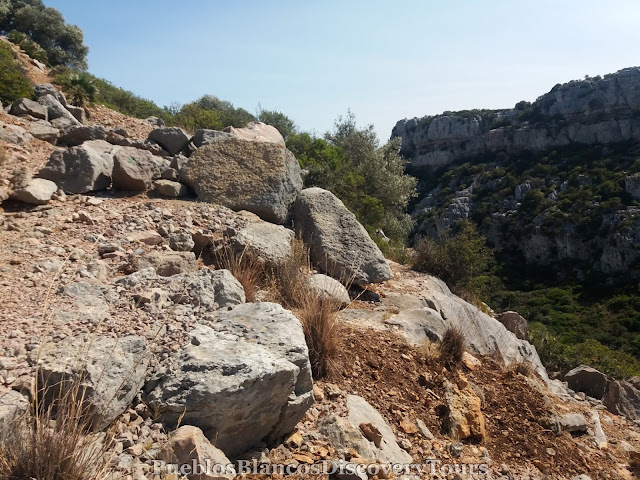
The path starts to become rockier.
Left and right of us the dense vegetation and beyond the high cliff walls.
Natural forces have broken away this section of the path.
Carefully we walk on.
With astonishment we wonder, by who, when and why this path was laid.
Soon after the path has totally disappeared.
A view to the west end of the gorge.
A view towards the east and to the coast.
Every so often, marked stones help us find the way through the gorge.

Wind and rain has formed the Karst rock over millenniums.
Fascinating scenery!
With care we scramble on.
We find ourselves walking in the dry river bed.
At times again we find the path is fairly intact.
The many nooks and ledges make an ideal habitat for various forms of wildlife and birds of prey.
On the cliffs ledge we notice a large eagles nest.
Fascinating to see how vegetation clings onto the sheer rock.
The gorge seems to open up as we reach higher grounds.
A view along the gorge and towards the Mediterranean sea.
We come across some man made structures.
It looks like some kind of reservoir.
It was said that in the 1970s, prospectors were drilling for petroleum.
Luckily it didn't happen!
This area is also the widest part of the gorge.
If you look upwards you can observe birds of prey skimming the rock-face and soaring in the sky. Especially in spring and autumn migrating birds rest in this area before they carry on with their journeys north or south.
A panoramic view of the karst mountain of "Sierra de la Utrera".
We leave the plains behind and walk further upwards.
Another view along the gorge towards the coast.
The footpath, now turns into a service road and it is easy to follow.
Standing at the western end of the gorge the board was very informative.
The explanation is given also in English.
In the distance are the modern-day giants (the windmills) as they utilize the winds around the "Sierra de la Utrera".
The rugged terrain turn into rich farmland.
We noticed some ruins above us and we followed a narrow path up to see.
A view towards the Mediterranean coast again.
We could just make out the village of Jimena de la Frontera in the distance.
Below us the western entrance to the gorge.
We take another look at the fascinating karstic panorama,
before we head back the way we came.
Going down we get a different perspective of the gorge again.
Mediterranean Dwarf palm, Palmera enana
After we reached the bottom of the gorge again we follow the road towards the left and to the Roman Bath, "Baños de la Hedionda".
On the way we pass the chapel of "San Adolfo".
We notice some derelict buildings on the left side of the road.
At this point we left the road and turned towards the river towards the right.
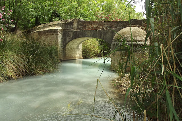
After we walked through the thicket we found a beautiful old bridge,
(maybe from the Romans!)
What an amazing setting!!
The smell of sulphur waters (like rotten eggs) is all around us.
Quite surreal!
The milky water, the lush green vegetation and the old stone bridge.
A bit further along, the luminous and whitewashed structure of the
Roman baths "Baños de la Hedionda"
The sulphur spa is covered by a building, which made it easier to enjoy for bathers. The waters are supposed to have a healing purpose, especially for skin problems.
It was said that the Roman Emperor "Caesar" had it built, and used these sulphurous waters to heal his ailments. It was renovated by the Arabs.

Some advice for bathers.
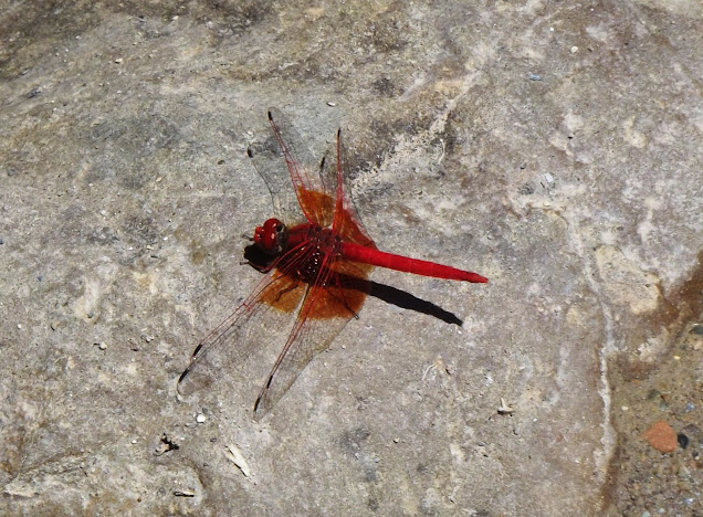
On a stone we capture this beautiful red dragonfly.
After some relaxation we leave this extraordinary place.
From the car park we look across to the wine orchards of Manilva.
Map of the hike
 |
| Click on link: Wikiloc: Sierra de la Utrera, Casares |
How to get to the Roman Baths "Baños de la Hedionda"


No comments:
Post a Comment