"El Risco"
the Torcal of the Serranía of Ronda near Júzcar
the Torcal of the Serranía of Ronda near Júzcar

Prologue:
El Risco (the Crag), at 1400 meters above sea-level, is a fascinating landscape of limestone rocks, which are in the mountains of Sierra del Oreganal between Catajema and Júzcar in the Serranía de Ronda, Málaga province. These mountains separate the Ronda plateau to the north, from the Genal valley to the south.
This rocky terrain has always fascinated us, it looks so formidable and untouched, therefor we were happy to have found this trail in which we were able to have a glimpse into this fascinating limestone landscape.
The limestone rocks are the result of the accumulation of shells and skeletons of marine animals deposited in successive layers on the floor of an extensive sea which covered this area around 200 million years ago (during the Jurassic Period).
It is a barren landscape, the vegetation which does grow here has to withstand harsh conditions (very dry hot summers and cold and sometimes freezing temperatures in the winter.
This rocky terrain is an ideal habitat for the Spanish Ibex (Cabra Montes) and various types of birds, ie: Rock Bunting, Black Wheatear, Crag Martin, Bonelli's Eagle, Eagle Owl, Griffon Vulture and many more.

The iconic rock sculpture which is known as the Eagle "el Águila" can be found here.

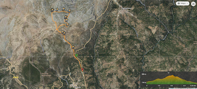
The Hike is approx. 5,3 km moderate to high (due to its terrain) circular walk,
with a difference of 250 meters in height to an altitude of ca. 1000 meters.
We took a comfortable 4h25min, allowing for stops and a picnic.
 |
| Click on link to see the map Wikiloc: El Risco, Júzcar |
Take Note:
Because of its location and at a high altitude, El Risco can be quite a bit cooler than the coast.
The Hike itself is moderate but appropriate shoes and clothing are advisable as well as to take water along with you.
Also it is highly advisable to stay on the marked walkway, as the risk of losing yourselves in the maize of rocks is high, especially in bad visibility like fog or low cloud.

Directions:
- From Marbella AP-7 you drive west, and in San Pedro de Alcántara you turn towards Ronda A-397.
- After approx. 48 km/45 minutes drive, turn left onto MA-7306 towards Parauta and Cartajema. You find yourself on the Legacy Route of Fray Leopoldo de Alpandeíre (Ruta del Legado de Fray Leopoldo).
- You bypass the village of Cartajema, and after 5 min. on the right hand side you arrive at the signposted exit to El Risco , on the outskirt of the blue village of Júzcar in the upper Genal valley.
- You can leave the car here or you drive up a further 1.8 km on a gravelled road, on the top you will find a large parking area.

Leaving the main Ronda road, we follow the scenic road MA-7306 towards Cartajema and Júzcar. On the right side, the unmistakable karstic rocky terrain of the Sierra Oreganal and on the left you overlook the river valley of the Genal and the Cobber forest (el Bosque de Cobre), especially very picturesque in the autumn.

As you near the blue village of Júzcar, you seem to become enveloped by the chestnut trees.

The Genal valley is famous for its chestnut trees which have been cultivated for hundreds of years and it is in the autumn that the Copper Forest (el Bosque de Cobre) of the Serranía de Ronda, comes alive. Not only is the harvesting of chestnuts in full swing, and many businesses in the region of the Genal river valley depend on it, but also the natural phenomena, when the leaves of the chestnut trees change their colours from green to yellow to orange and brown, can be observed.

You find the turnoff to El Risco just before you reach the Smurf village of Júzcar. Here you find an information board with all the birds you are able to see in this area of the Serranía de Ronda.

A view across the chestnut orchard towards the east and the village of Cartajema.

We decided to walk up the gravelled road, ahead of us "El Risco".

A view back from where we came and across towards the village of Pujerra.

This view is across the Copper forest (Bosque de Cobre) and to the snowy mountains
(Sierra de las Nieves).

After 1,8 km we reach a high plateau where we find a car park and a farmhouse.
From here there are various options of different walkways.

We take the route towards the right and along the south-side of the mountain.

As we look across an olive grove we face the rugged terrain of "El Risco".


A view towards the west along the high plateau.

We follow the red arrow.

We pass through a gate.


After approx. 400 meters we follow a footpath uphill.

In front of us, the unknown!

We also set a mark and left a stone on top of the pile.

An almond tree with its autumn look.

There are some nuts remaining on this tree.

It is astonishing to see olive trees, almond trees and even wheat fields at this altitude.

Steadily we follow the rocky path.

Through another gate.

The track is fairly easy to follow and sign posts direct you in the right direction,
but it is recommended to stay on the pathway.


A wild olive tree (Acebuche) offers the passer-by some shade.


The tree is full of black olives.

The panoramic views are just amazing.

A view west in the direction of the Sierra de Grazalema.


Natural elements have formed many nooks and crevices in the limestone rocks.

The path leads us higher and into the labyrinth of "El Risco".

At times the track is hardly visible and we keep a lookout for the sign posts.

It is certainly an easy area to get lost in.


We follow the narrow track through the rocky terrain.

The vegetation is sparse, only low shrubs can grow here,
like Rosemary, Wild Sage, Lavender, Broom and Rock rose ....
 |
| Hawthorn bush (Arbusto de Espino) |
These man made rock stupas help you to stay on the right path.

and upwards we climb.


Truly fascinating, these rock sculptures made by nature.

A panoramic view of the south side of El Risco.

Carefully we carry on.


about ready to take five!


A view down to the Finca which we passed earlier.

As we reached the top, we came to realize the vast extent of the Karst landscape.

In front of us the iconic rock sculpture of El Risco

It is known as The Eagle,"El Águila".


The giant rock eagle looms over us.

Some information about this unique terrain.

Succulents, moss and lichen grow in the many nooks and crevices of the rocks.


Pretty lilac flowers make a nice contrast in this rocky landscape.
 |
| Autumn crocus, Azafrán silvestre (Colchicum autumnale) |

We feel dwarfed standing within this bizarre landscape.


Its amazing to see where some plants take root!

High above us, a huge Ivy plant embraces the rock.

Ivy, Hiedra (Hedera helix)


A Hawthorn bush full of red fruit.


In spring you will find Jerusalem sage bushes in bloom.

Walking through the maize of the upper part of El Risco,
and always on the lookout for the sign posts.

We reach a large man made circle of stones.

Eras are paved circular areas located in well vented places.
They were used by farmers for threshing cereal harvests.

Life for the mountain people was very hard due to the harsh environment. The farmers had to carry the cereal bundles on their backs or by pack mule to this high plateau. They chose this location for its airiness, the wind helped to separate the grains from the husk .


A panoramic view east and towards the snowy mountains of
Sierra de las Nieves.


This view is across the Bosque de Cobre , the white spec being the village of Pujera.


Now we follow the path west and downwards.

Every so often we stop to take in the fantastic views.

We look west over the high plateau and in the distance we just can make out the villages of Benarrabá and Algatocín on the Gaucín - Ronda road A- 369.

A different perspective from this point.

A view south towards the Mediterranean coast.

Towards the west and the Nature Park of Sierra Grazalema.

We found an ideal place for a picnic,

and at the same time to enjoy the tranquil surroundings.

Certainly enjoying every minute of this unique place.

Fascinating, like giant building blocks!

Natures art work!


After, and well rested we make our decent.


A red arrow helps us to find the way through the maize of rocks.

A view back from whence we came from.


Below us a large circle of an ancient Era.

We searched the barren terrain for mountain goats "Cabra del Montes"


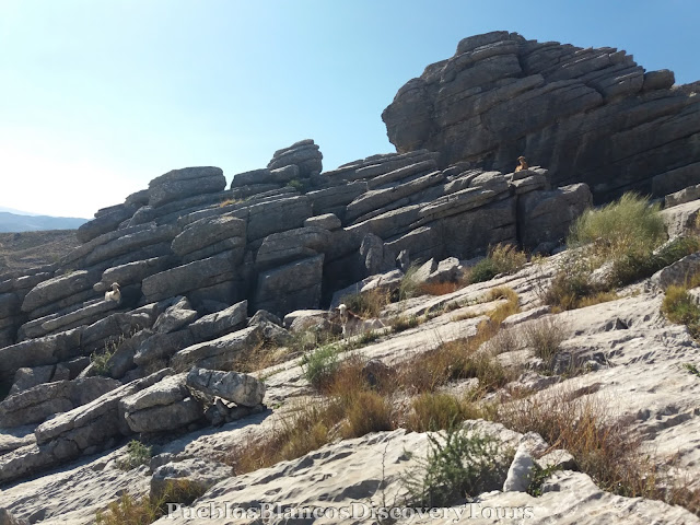


A panoramic view of "El Risco".

We reach the starting point of the trail again.


How to get to Júzcar, Serranía del Ronda

We searched the barren terrain for mountain goats "Cabra del Montes"


The path leads us out of of the rocky maize.


As we made the decent we were watched by some domestic goats.


From this point we are able to view the road A-397
Ronda-San Pedro and the Sierra de las Nieves.


A panoramic view towards the east and the copper chestnut forest.


We reach the starting point of the trail again.

We find ourselves again on the road down whence we came on.

A olive tree full of black olives.
In the distance the Sierra de las Nieves range with its highest mountain Torrecilla (1919 m)

A panoramic view over the Copper forest "El Bosque de Cobre".

A view east across a chestnut orchard and in the distance the village of Cartajima.

The white village of Parauta, which we passed on our way back on the Ma-7306.

The map of the hike
|
| Click on link Wikiloc: El Risco, Júzcar |

No comments:
Post a Comment